
From protecting the homeland to fighting wars abroad, the U.S military relies on technology in space to be competitive, as well as to safeguard the United States from potential threats. American adversaries, Russia and China, aren’t slowing down in the race to push the limits of space technology. Just in the last year, we’ve already witnessed hostile activity. This includes both the development of new weapon systems in space, as well as the destruction of a low-orbiting satellite from (what was believed to be) a Russian ground-launched missile.
There have been many incredible breakthroughs in space technology, from reusable rockets to advanced missile warning systems. The United States Department of Defense uses many of these innovative technologies to give them a competitive edge and keep the U.S. homeland safe. However, satellites continue to be the most essential technology for enhancing public safety.
Commercial Space Remote Sensing: The DoD as a Future Customer
While we’ve seen many innovative technological advances in satellite technology, the commercialization of space has arguably had the biggest impact on the industry. The space economy once existed solely in the public sector, but private organizations have taken advantage of the major drops in cost for satellite manufacturing in recent years.
Additionally, we’ve seen a shift in the space technology market to one that is service based. The U.S. government has been examining ways in which it can utilize innovations in the commercial space industry to either replace or add on to current government space systems.
Many satellite companies are outsourcing ground station services and cloud-based data processing to other companies. The DoD can similarly utilize commercial space remote sensing companies to capture, downlink, store, secure, and extract satellite data.
Eye From the Sky: Enabling Earth Observation and Reconnaissance
The US government uses satellite technology for a wide range of applications, including navigation, communication, space exploration, meteorology, and earth observation.
One of the primary ways satellites are used today is for observing and gathering data of the Earth from above. Through remote sensing, we can capture images of large areas of the globe, which provide us with information that is difficult or impossible to gather from the ground.
From a national security perspective, having the ability to easily capture images of the Earth enables the DoD and other agencies involved in public safety to improve situational awareness. The DoD can better monitor and react to potential threats. And with the images we retrieve from satellites, we can use data analysis and photogrammetry to better understand the world and create accurate maps and models.
Responding to Natural Disasters
Satellites save lives in natural disasters. With remote sensing, meteorologists can forecast hurricanes and large storms. Forest fires can be detected before they reach homes or cause further damage. We can get real-time updates on road conditions, including icy conditions or landslides.
With this information, people are given precious time to leave the area and find safety. We can close dangerous roads. Additionally, emergency response teams can get to the scene faster, helping mitigate damage and save even more lives.
Satellite imagery gives us the foresight to identify vulnerabilities. By exploring and analyzing the landscape of a region and creating scale models, we can gain valuable insights into what might happen to a body of water if rainfall increases or what path a fire might take based on vegetation.
When disaster does strike, satellites can aid in search and rescue missions. Remote sensing technology can also help governments and emergency response teams assess the damage that has happened and develop a recovery plan.
Information gathered during a disaster also provides valuable data on what contributed to the disaster and how we can better prepare or mitigate these situations in the future. We can even analyze historic data to compare disasters over the years and create strategies on how to make vulnerable regions more resilient.
Aiding Military Missions
Reconnaissance satellites, often referred to as spy satellites, are Earth observation satellites used specifically for military use. These satellites are often used to gather intelligence information on the activities in foreign countries.
The Issue of Cybersecurity: Securing Satellite Data
While the commercialization of space has had many benefits for national security and research development, this shift has increased the concern of cyberthreats. While attacks on satellite data in space aren’t common, there have been events of both cyber and physical attacks on satellites and space systems in the past.
However, some of the biggest threats to space data exist on Earth. Ground stations, where data captured by satellites is downlinked, are vulnerable to cyberattacks.
Many U.S. satellite companies currently utilize foreign ground stations, which has led to a long list of issues. Is sensitive data safe at a foreign ground station? What can satellite companies do when regulations set by the U.S. contradict those set by the nation where the ground station is built?
These satellites help the DoD to look out for possible terrorist activity and assist in homeland security missions. In war, these satellites allow the military to better target enemy forces and map out the battlespace. Optical-imaging satellites can detect enemy weapons, missiles, and potential nuclear threats.
In response to many of these concerns, U.S. senators recently introduced bipartisan legislation called the Satellite Cybersecurity Act, which would require the Cybersecurity and Infrastructure Security Agency (CISA) to release resources and recommendations on how companies can better secure their networks. Additionally, this act would require the Government Accountability Office to perform a study on the federal government’s role in supporting cybersecurity in the commercial satellite industry.
The Highest Latitude Ground Station in the United States
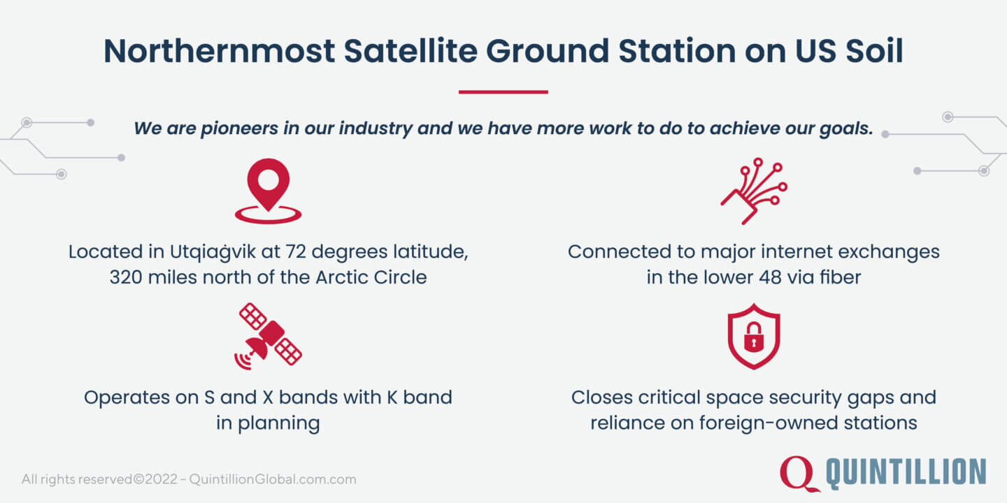
For American companies launching polar-orbiting satellites into space, a ground station on US soil is the most secure option for data downlinking and processing.
Another factor to consider is data download speeds and network latency. Many American ground stations are not in the ideal location for downlinking satellite data, and, as a result, companies that handle large volumes of data risk waiting long periods of time to process data. A lower latency network is achieved by reducing the distance between a ground station and a satellite.
The Quintillion HiLDA ground station checks both of these marks. Utqiaġvik, Alaska is the northernmost point in the United States, meaning that it is the closest location in the country to satellites in space. And it is this location, at 72 degrees latitude and 320 miles north of the Arctic Circle, where the Quintillion ground station was built. It currently has one 3.5 antenna that supports S and X band transmission, and it has the potential to see up to 12 satellite passes a day. With its strategic location, there is potential for this facility to expand to a multi-antenna, multi-band teleport that can be used for a wide variety of applications: including national security.
Looking for a satellite downlink solution for your American company? Contact Quintillion to learn more about the HiLDA ground station.